Search

Showing posts sorted by relevance for query las virgenes. Sort by date Show all posts

June 08, 2014

Photo Essay: How the Dry Valley Gets Its Water

Everybody calls LA a desert (correction: it's a semiarid, sub-mediterranean climate), and in a drought year like this one, it sure feels like it. We don't have much rainfall of our own (and this year, we don't even have the marine layer that gives us May Gray and June Gloom), and until we can figure out how to remove the salt from the Pacific Ocean water, we have to import ours from up north.

Depending on where in the LA metropolis you live in, you might get your water from one of the aqueducts that receive their supply (eventually) from snowpack melt up in the northern mountains. When it snows. Which it hasn't much this year.

Some get theirs from the LA Aqueduct, and others – like the Las Virgenes Municipal Water District (which covers the cities of the West Valley and the largely unincorporated mountainous area west of LA) – get it from the California Aqueduct.

But since none of the houses or businesses have long straws to dip directly into their respective aqueducts or reservoirs, the water has to be delivered to them somehow.


The LVMWD not only provides the water itself, but a whole water service, including pumps, valves, 2500 fire hydrants, and maintenance of all of the above. Also, by state law, they have to restrict urban water use by 20% by 2020, which means cutting down on irrigation, sprinklers, lawn watering, leaks, etc.


The water delivered to those in the LVMWD comes from the area's regional water wholesaler, Metropolitan Water District, and travels east to west through a reversible pumping system, which can switch the direction from west to east in times of maintenance or other issues.


The LV #2 Connection, built in 1992 in Calabasas, is where the LVMWD facilities begin...


...and features a total of three pumps, only two of which run at any given time.


The water is pumped at a force equivalent to 600 horsepower, which is necessary because of the mountainous nature of the area, whose residents at high elevations can't receive gravity-fed water (like from the LA Reservoir).


This serves the 122 square mile service area of the water district, which has no native supply of water, making it essential to import it all.


In an underground chamber, you can find the pressure valves...


...and the large pipes that can deliver the water in either direction (west or east).


There are nearly 300 miles of pipes to move water around the entire district.


At the Cornell Pump Station, there's a big diesel engine that's like a big car with a V8 engine...


...that powers a catalytic converter-type filtration system...


...along with an electric pump...


...which is employed before the gas pumps.


This is where they can switch the direction of the water flow, from east/west to west/east.


Depending on the water demand at the time, the supply is either pumped directly into homes...


...or to the Las Virgenes Reservoir in Westlake Village.


Built between 1970-1972, at 120 feet deep at full capacity (with 20 feet of unusable deadwater at the bottom), it holds a big enough water reserve that could supply water for six months in an emergency, which is about three billion gallons.


The water is contained by two earthen dams including the Saddle Dam and the dam at Three Springs Park.


Unlike the LA Reservoir, this reservoir is uncovered, but also protected under tight security: fenced off from land-walking wildlife (although birds can get in), human contact is prohibited, which means no recreation at this nice-looking lake.


Along the Saddle Dam is the Westlake Filtration Plant...


...which filters and disinfects (again) any water drawn from the Las Virgenes Reservoir.


Built in 1989 and in operation mostly during the summer (when water is needed most)...


...it's capable of processing up to 15MM gallons of water per day.


First, the water from the reservoir comes in through the dam and is filtered through units that use diatomaceous earth (fossilized remains of hard-shelled algae that is baked and ground up into a fine white powder) as filtration media. DE has other common household uses as an absorbent, insulator, filler, and abrasive – and is even available in food grade (e.g. for use as an insecticide).


After filtration, the water goes through disinfection using chloramines (just like at the LA Reservoir filtration plant), and then out to thirsty residents.

Incidentally, the Las Virgenes Reservoir and filtration plant were the last place that Huell Howser visited before his death, and were the last location featured in his California Water series (starts around the 18 minute mark).


Related Posts:
Photo Essay: Keeping LA's Water Supply Drinkable (and Accessible)
Photo Essay: The Power Plants of the St. Francis Dam Disaster

October 11, 2012

The Steep Climb Through the Cave of Munits to Castle Peak

I hadn't been doing much hiking over the last few weeks. I'd come up with every excuse not to hike - it was too hot, I didn't have a car, gas was too expensive, I was too tired - all of which were true, but as much as I missed hiking both physically and mentally, it was easier to keep not hiking than to hike.

At least by myself.


Fortunately, I had the opportunity to join a group last weekend on a cave hike in the Santa Monica Mountains. Although the group leader promised it would not be a "difficult" hike, he did warn that if we were afraid of heights or not used to hiking boulders, this might not be the hike for us.

Of course, me being who I am, that meant it was exactly the hike for me. At least if I freaked out or fell, I wouldn't be alone.


Castle Peak is imposing, even from the street...


...though it's an easily graded hike through the Upper Las Virgenes Canyon Open Space Preserve to get to the Cave of Munits, which you hike through to get to the ridge trail that leads you up to the peak.


The cave still holds great significance to the Chumash Native American people, who occupied the area for 10,000 years.


It's a steep - and difficult for me - climb up into the cave, requiring fellow hikers lifting me by my upper arms as I scraped knees, shins, and elbows across the rock.


Once inside the cave, it's easy to imagine a Chumash shaman making the cave his home and never leaving.


Through the other side of the cave, the elevation gain isn't tremendous to get to Castle Peak, and the entire distance of the hike is only about three miles, but it is a tightrope walk along the ridge trail, and requires lots more climbing.


At the top, there are stunning 360 degree views of the canyon and the West Hills community below.


If I hadn't been with a group, I wouldn't have been able to complete the hike. At times, the trail seems to disappear altogether. On the rocks, you have to find just the right spot to rest your boot toe and dig in your fingers, and sometimes you need someone standing next to you to tell you where that spot is.

At one point, I had to ask Mike, our hike leader, "Am I going a normal way or a crazy way?" because it just seemed too vertical and too difficult to be right. He assured me, "That's normal way."


Sometimes, you need a hand to hold onto, or a boost from behind. Sometimes, you just need to know that hand is there if you need to use it.


But for all of the difficulty I had - with the strain of climbing, the sweating, the scraping, the vertigo - completing the hike was a satisfying personal challenge for me. At no point was I way in the back of the group, or (God forbid) left behind (see: the Bridge to Nowhere). I didn't quit, nor did I consider quitting (though a small group of fellow hikers did quit).


And thankfully, we didn't have to go back down the way we came, skipping the passage back through the cave in favor of a gentle trail through a dry, brittle prairie...


...where we laughed and smiled and congratulated each other on a job well done.

Three hours later back at my car, covered in dirt, sweat, scratches and bruises, I was ready to conquer the world.

To Like Avoiding Regret on Facebook, click here.

November 25, 2022

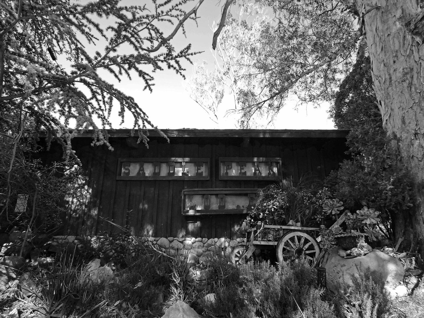
A Turkey-Free Thanksgiving at a Storied Mountain Lodge Outside of LA

When I was working as a field agent for Atlas Obscura a few years ago, I really wanted to host a dinner at Saddle Peak Lodge—specifically, a game meat dinner. 

I was fascinated with intimidating foods and thought that a communal experience would create a comfort level that I, and others, might not have alone. 

I couldn't get that event approved, so I finally went to Saddle Peak Lodge on my own a few years ago—but I wimped out both gastronomically and financially and just went to brunch. I don't remember the meal, but I'm pretty sure I had eggs (and not, like, ostrich eggs).

So, I've felt like I hadn't really experienced the restaurant—and when the 2018 Woolsey Fire swept through the area, fortunately sparing it, the urgency to return intensified.


I finally made it back yesterday, for Thanksgiving dinner—not because this colonial holiday is important to me (it's not), but because I felt like I needed the excuse of a special occasion to splurge on it. And since it's a Michelin star-receiving establishment, it also charges Michelin star-level prices.

June 08, 2017

Photo Essay: The Ghost Town of Cornell and Its Abandoned Lake Enchanto (Updated for 2022)

[Last updated 12/26/22 11:37 PM PT with info on the reopening of Peter Strauss Ranch.]

Wherever you find water in Southern California, you're bound to find a town nearby.


And whenever that water dries up (or is taken away), you'll find a ghost town.


Such is the case with the hamlet of Cornell, just north of the Santa Monica Mountains and adjacent to Malibu wine country.


The Triunfo Creek used to run through here, this canyon that shares the same name, for thousands of years while the Chumash inhabited it...


...as well as throughout the land grant era, when this place was known as "Rancho Las Virgenes."


This was the site of an old wagon pathway, so it started seeing some travelers passing through—and even some folks who came here to stay.


When the local community wanted to build a schoolhouse in their new hometown, they found a patron in Ezra Cornell, founder of Cornell University in New York—and so became the town on Cornell, named after him in gratitude.


By 1884, Cornell had become enough of a town to necessitate having its own post office...


...which operated out of Hank's Country Store (also the trading post for the nearby Malibou Lake Country Club).


In 1911, prospectors were looking for oil but found hot springs instead.


This remote area of the mountains was largely inaccessible to many until 1925, when William Mulholland opened up a highway that allowed motorists to drive from LA to Malibu.


Then called the "Mountain Highway," it was a new, exiting, direct route "from Griffith Park to the sea."


Although Cornell is no more (at least not officially), you can still visit the country store—which was rescued from shutter in 1970 by Tom Runyon, the son of East Coast coal barons who'd come out to the Wild West.


He opened The Old Place Restaurant in its stead and has been feeding locals, celebrities, and tourists alike ever since.


Today, you can still grab some grub at The Old Place—at the long, antique bar or in the private dining room (aptly named the Mail Room)—or you can grab coffee from the old truck out back...


...as you listen to the the peacocks that still call Cornell home.


Not coincidentally, a year later after the opening of Mulholland Highway, an automotive engineer and race car builder, Harry Miller, bought the parcel across the street.


In this glen shaded by oaks and sycamores, he built several of the structures that you can still see today on the property to transform it into a weekend retreat from his L.A. home and automobile factory.


Those include the tower by the front gate [Ed: which survived the Woosley Fire]...


...the stone ranch house (*Update: The Woolsey Fire took the ranch house, leaving only the stone walls and fireplace/chimney, which were since demolished)...


...the aviary...


...which no longer holds any exotic birds [Ed: and survived the Woolsey Fire but was partially crushed by a falling tree]...


...and a pool that was once the largest of its kind in the West [Ed: and survived the Woolsey Fire].


When filled with water, it could hold as many as 3,000 swimmers.


But the pool is empty now, too...


...overgrown with weeds...


...and fenced off.


Miller's patented carburetor and car designs had made him both a millionaire and a hero among Indy 500 racers; but, in the wake of the Depression, Miller went bankrupt in 1933 and lost his ranch.


Throughout the 1930s, '40s, and '50s, the property changed hands again and again: its name changing from “Shoson” (a combination of the surnames of its then owners, attorney Warren Shobert and cinematographer Arthur Edeson) and “St. Bernadine's Fairy Tale Land” to "Cornell World," a theme park featuring replicas of the various wonders of the world.


It was a would-be Disneyland even before Walt had his infamous light bulb moment at the Griffith Park Merry-Go-Round.


The local source of water, Triunfo Creek, was dammed to create not one but two lakes (one in Cornell and one down in "Malibou")—and that proved successful for tourism, but only for a while.


In Cornell, Here, the ranch eventually became known as “Lake Enchanto,” a family-friendly amusement park that reportedly drew hundreds of visitors and performers like Johnny Cash and Willie Nelson. who performed on its terrazzo-tiled patio [Ed: which survived the Woolsey Fire].


But, unable to compete with other, larger amusements and resorts in the area, the business went belly-up and closed in 1960. Its owner, lawyer Charles Hinman, ended up in jail. The property languished, with squatters (including members of the Manson family) taking it over and Cornell becoming a haven for rowdy hillbillies.


We have TV actor and producer Peter Strauss to thank for wrestling the ranch away from the transients and other ne’er-do-wells of its checkered past, buying it for a mere $200,000, and restoring its structures to their original condition and adding a cactus garden to the driveway. [Ed: Which miraculously survived the Woolsey Fire.]


Strauss became the last private owner and resident of the property in 1977, the year after he starred in the TV movie Rich Man, Poor Man (filmed at Malibou Lake, as was Frankenstein).


In 1983, he sold it to the Santa Monica Mountains Conservancy, and in 1987, the National Park Service acquired it for inclusion in the Santa Monica Mountains National Recreation Area and named it after him.


Long before that, a rogue Lake Enchanto employee had unbolted three of the kiddie ride cars to take home with him—which is a good thing, since the remaining ones had been left to rust on an embankment by the road and are now officially missing or gone altogether.


But as of sometime in 2017, the rescued ones ended up strung up above the tasting room at Cornell Winery, next door to the old post office.


Now, though, the closest operational post office to the unincorporated community of Cornell is in Agoura Hills, the city with which it shares a zip code and an area code. But that's really just a formality—because if you address a letter to Cornell, CA, the mail carriers still know where to deliver it.


And if you're looking for the old one-room schoolhouse, it's been converted into a private residence (and expanded), but you can still find it along Cornell School Road.


The local hot springs still bubble, though nobody travels very far to smell like sulfur anymore.


The old hot tub has been filled in.


But the water runneth—and it's not runoff, like the waters found in Malibou or Century Lake. It comes from within the earth, and although it's not "hot" per se, it's pretty warm. Just now it's surrounded by a mobile home community.

And still no oil—which explains why Cornell never became a boomtown.

If you want to know more about the history of this area and more, check out the book Three Magical Miles by Brian Rooney, which is sold at Cornell Winery and various other local retailers and online. I had the pleasure of traveling those three miles with Brian and am indebted to him for helping me find the schoolhouse, hot springs, and salvaged amusement park cars.

Update: In November 2018, the Woolsey Fire ripped through Peter Strauss Ranch. The ranch house is destroyed (see above) but the park has reopened. Cornell Winery and The Old Place across the street still stand. For recent pics by Ruben Vives from the LA Times on Twitter, click here

Related Posts:
Photo Essay: Paramount Ranch & Raceway
Photo Essay: Oakridge, An Old Hollywood Celebrity Ranch
Crossed Off the LA Bucket List: M*A*S*H at Malibu Creek State Park