Search

Showing posts sorted by relevance for query burro. Sort by date Show all posts

April 13, 2025

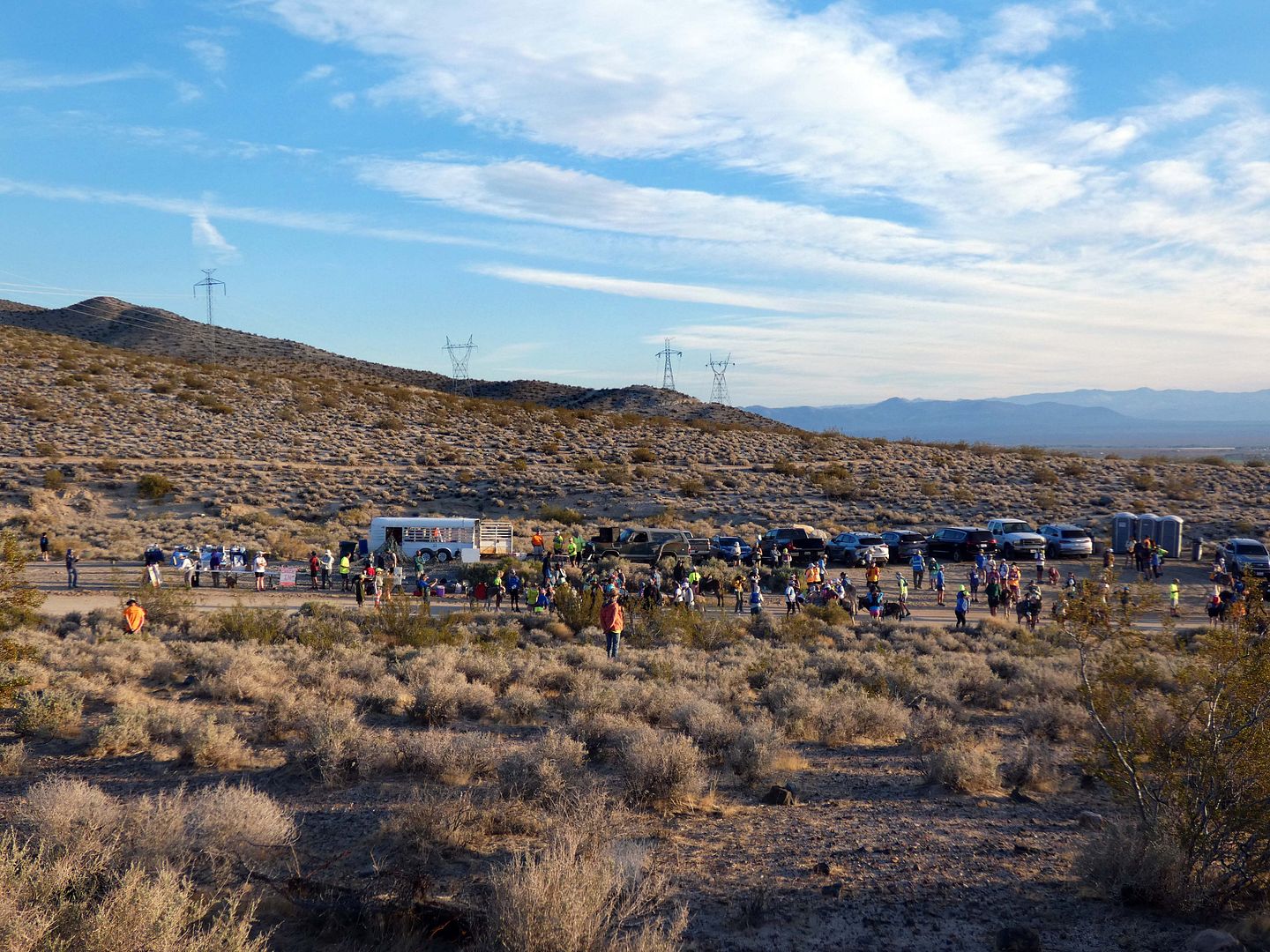
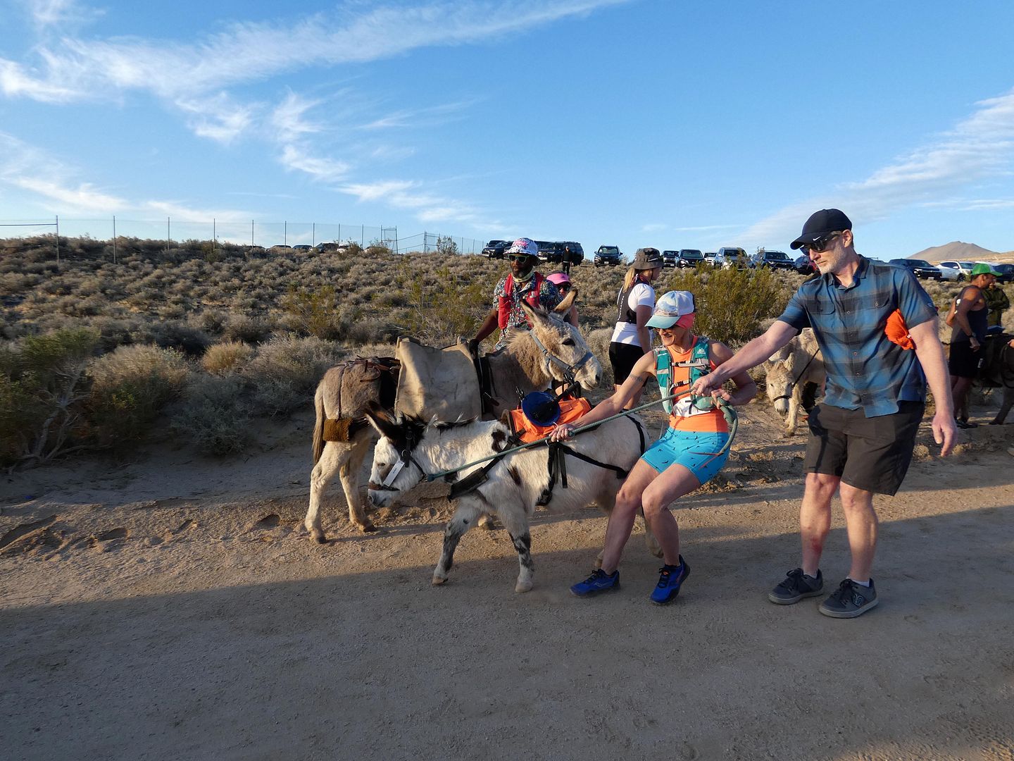
Photo Essay: Donkeys Hauling Ass at California's Run With the Burros

Ever since I read the memoir Running with Sherman: The Donkey with the Heart of a Hero, I've been interested in witnessing burro racing. That's when runners take to the trail with a donkey for a man-versus-man/animal-versus-animal competition—one that's popular in Arizona, Colorado, and now California.

I had my chance this weekend thanks to the non-profit California Breakfast Burritos, which has been focused on bringing pack burro races back to the Golden State since its founding in 2018. 

 
There's a long tradition of burro racing among 19th-century miners—locally, in Randsburg, Death Valley, and the Eastern Sierra communities. But this version has been around since 1949, when it was used as a marketing gimmick to bring tourism to declining mining communities (and to find a use for those working burros the miners left behind). 


June 28, 2018

Photo Essay: Digging Into the Silver Royalty of Nevada's "Other" Side

I'll admit that it was my love of trains—not mines—that brought me to the "Queen of the Silver Camps," Tonopah, Nevada. And it wasn't just the fact that I was stopping over there on my way to take a "traincation" in Ely.


Because I'd learned about the Tonopah and Tidewater Railroad back in 2012 while doing some exploring around Death Valley—and even though that Borax-owned rail line never actually made it to Tonopah, walking along its abandoned right-of-way at China Ranch put Tonopah on the map for me, so to speak.

April 20, 2025

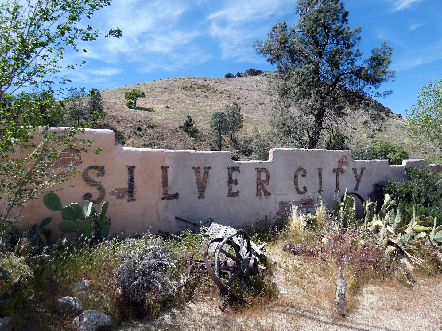
Photo Essay: Silver City, A Ghost Town Made of Pieces of Other Ghost Towns

When I first moved to California, some places just seemed so far away. It was impossible for me to wrap my head around making a day trip to Joshua Tree or Palm Springs—a three-hour drive each way. But over the past 14 years, my home state has continued to feel smaller and smaller, easier and easier to tackle. 

In April 2014, I made a detour from the Eastern Sierra to try to see Silver City Ghost Town in Bodfish, California, located in the Kern River Valley of the Southern Sierra. I'd gotten there too late in the day to catch it before it closed or to even photograph it in daylight. And it just seemed so out-of-the-way that it took me 11 years to try again. 

 
This time, I planned my trip a little better and got an earlier start, as I headed home from the early-morning Burro Run I'd attended in Indian Wells Canyon. 

June 24, 2021

The Power of Quitting

Nobody likes a quitter. 

We're expected to stick with whatever life hands us, no matter how much it sucks.

People quote Winston Churchill saying, "If you're going through hell, keep going" like some kind of encouragement. 


Not me. I'll be a quitter till the day I die. 

July 31, 2018

Photo Essay: A Sizzling Sunset Cruise on Lake Havasu

At the California-Arizona border, where the Mojave transitions to the Sonoran Desert, the construction of Parker Dam along the Colorado River in the mid- to late-1930s filled a floodplain and created Lake Havasu. It's not really a lake, though—it's more of a reservoir.

In fact, some might say that it's just a wider, deeper part of the Colorado River with more water in it and less of a current.

It makes for good water sports and recreation, not the least of which is boating but also jetskiing, paddleboarding, and the like.

I imagine it's something of a successful version of the Salton Sea—without the annual fish and avian die-off and resulting stench and fly problem.

In 1967, three years after founding the planned resort community of Lake Havasu City, chainsaw mogul Robert McCulloch bought a bridge—not so much to span the body of water, as there was actually a peninsula in its place, but to create an attraction for tourists and potential homebuyers and landowners.


But it wasn't just any ol' bridge. McCulloch literally bought the London Bridge—the so-called "new" one from the 1830s—which wasn't so much falling down as sinking into the Thames and had to be replaced. He then dismantled it, transported the pieces to Arizona through the Panama Canal and into the Long Beach Harbor, and then had it painstakingly reassembled, each piece having been numbered and catalogued. 


The reassemblage was completed in 1971, along with an entire "English Village" that served as a quaint, open-air gateway to it. Many of the temporary buildings have since been torn down, but the scale replica of the Buckingham Palace gates still stands.


And there are plenty of other small touches to make you feel like you've crossed over to the other side of the pond...


...including a couple of red telephone booths (which you'd think would be extinct by now)...


...and plenty of Union Jacks alongside the Stars and Stripes and the Arizona State Flag.


Besides the fact of its mere existence here in Arizona, there's plenty of intriguing trivia to be learned about the London Bridge—including that it's only clad in its original English (actually "Haytor") granite. Inside, it's hollow, supported by reinforced concrete (ensuring that it will not, in fact, fall down).


Its five stone arches bear the strafing scars from the London Blitz bombings by Germany during World War II. And while some areas of the granite are dark while others are light, it was actually all dark when it arrived in Arizona, thanks to London's soot problem. In the nearly half-century since its relocation to the arid desert, the sun has bleached out many of those old, dark stains.


We were stupid enough to visit Lake Havasu at the end of July, in sizzling summer heat. When we arrived to town, it was 112 degrees outside. There would be no walking or exploring until sunset—at which point our group agreed on a late-in-the-day boat tour of the lake, its bridge, and whatever else there was to see.


Shave ice, chilled bottled water, personal cooling fans, and the setting sun helped. But sometimes, you've got to just give yourself over to the heat and be hot.


We set sail through the Bridgewater Channel, heading southeast into Thompson Bay towards the California state line...


...passing several of the 20-some-odd replica lighthouses that dot the shores...


...each providing a beacon for nighttime sailors and representing various real-life locales around the country.


We even spotted a (skinny) wild burro grazing for a snack on top of a shoreline hill.


And as the sun dipped behind the palm trees behind us...


...and we left it in our wake...


...we watched the crazy clouds ahead turn a rainbow of colors from yellow and orange to red and pink.


Approaching our turnaround point at Copper Canyon—which was once literally mined for its copper and settled as an encampment of miners—we spotted some kids jumping off the cliffs into the water and encouraged them with cheers and applause.


And after we turned around to head back to the dock, with most of the motorboatin' partiers wrapping up their daydrinking celebrations, we watched a spectacle of lightning that was isolated to just one storm cloud, hanging isolated and illuminated in the darkening evening sky.

Related Posts:
The View By Boat
Take Me to the River
S.O.S.

March 21, 2012

Photo Essay: On a Mission in the Santa Ynez Valley

Edith came to visit me from New York last weekend, and although I would've liked to have spent a bit more time in my hometown showing her around, we took a road trip up north.

We revisited Santa Barbara and the Santa Ynez Valley - the lower Central Coast of California - where I got into my first California car accident last year after only having my car for a month, where it rained so hard I had little desire to return.

A year later, the weather was more or less...the same.

But Edith and I were on a mission to explore. We were on a mission to outdrive the rain, overcome the rain, and in some cases, completely ignore the rain.


Despite threatening skies, we decided to drive to Lompoc to visit La Purisima Mission, a sprawling state park featuring a number of historic and restored adobe buildings that comprised the original compound, including the actual church...


....the Cuartel, quarters for unmarried soldiers who protected the mission...


... and various areas for workmanship including a blacksmith workshop, an oil press, and a tannery.


Outside, there's also a cemetery...


...and a ranch...


...featuring sheep, a burro, a bull...


...some turkeys...


...some cocks and an empty pigpen.

Farther afield from the animal yard, there are some restored Chumash Indian tule huts...


...and a Spring House, surrounded by several goopy cisterns.


There are actually 25 miles of trails around the Mission, so even though just a few minutes before it had been hailing while we sought shelter inside one of the buildings, we set afoot along dirt paths, across planks, and through trees.


I hate the rain so much that normally in LA, I would cancel all plans and just stay home. But Edith and I had arrived to the area through dense fog, and had started the day riding bikes through the rain, so we were already out.


And when we saw another storm in the distance, swiftly blowing towards us, we squealed "Get in the car!" and drove off, to our next destination.

Related Post:
Photo Essay: Past the Mission
Not What I Moved to California For

To become a fan on Facebook, click here.

April 08, 2014

Photo: Feeding the Wild Horses

California is home to growing herds of wild horses, which you don't always get to see because they're generally spooked by passing cars and approaching people. I first spotted some actually not far over the border into Nevada, in Beatty near Death Valley, but I'd never actually seen any in my home state.

How did they get here? Once upon a time, there were wild horses that were indigenous to California, but, like the camel and mastodon, died off. But then the Spanish explorers brought their domesticated horses over, many of which ran away (in distress, because of disaster or perhaps just the desire to be free) or were abandoned. Never captured, the mustangs bred, and their descendants now roam many of our open spaces. Although they are generally called "wild," technically they're "feral."

They're a federally protected wild animal, so in order to control the growing population, the Bureau of Land Management has established a program to capture them, rehabilitate them, and offer them up for adoption. Usually to control an overgrown wild animal population, an area will open hunting season (for deer, wild boar, etc). This is a descent alternative to that.


If you're lucky, you can spot some mustangs on the China Lake Naval Base in Ridgecrest, CA (another gateway to Death Valley), but security is so tight there, it's unlikely that many would ever actually get to go. 


As large as it is, the base has actually shrunken in physical size over the years, and some of its former Navy-owned land has been converted into a BLM-operated Wild Horse & Burro Facility...

November 19, 2018

Photo Essay: The Ghost Town That Won't Die, And the Animals That Keep It Alive

"Have you been to Oatman?" Robert asked. "No, but it's on my list."

A typical response from me.

Someone else asked, "What's in Oatman?" and all I could say was "I ferget."

Also typical.


But pulling up into the town of Oatman, Arizona early Sunday morning, it quickly became clear what attracts visitors to this Old West town along the Mother Road.


The burros.


"You can pet them," one of the shopkeepers said, "but they are wild."


In reality, they're incredibly habituated to the townspeople of Oatman as well as those who're just passing through.


They don't budge unless you've got food.


And then, they'll make a beeline for you.


Between feeding them directly and selling bags of pressed pellets...


...the locals keep the adult wild donkeys munching away...


...and discourage visitors from giving any food to the babies who are still nursing.


And what babies there were! Opal had been born three days before. She was too new to the scene to ask for food or to fear humans. Her coat was so soft.


The burros are a living reminder of the town's legacy as a late bloomer in the Gold Rush—first as Blue Ridge Camp, then renamed Oatman in 1909.


From about 1906 to the mid-1930s or early 1940s, their ancestors were used as livestock and labor—they worked in and around the mines, hauling rock, ore, and water.


By 1942, all the mines had closed.


When the prospectors and miners moved on, they left their hardworking companions behind, releasing them into the hills.


So what you see now is just a fraction of the herd of once-domesticated animals gone wild, coming down into town for a snack...


...timing their journey with the arrival of carloads and busloads of tourists exploring Route 66.


Like similar living ghost towns like Randsburg and Oro Grande in Southern California, Oatman embraces its history in spades...


...with thriving businesses like a saloon, roadside museums, and antique shops...


...with names like Jackass Junction, The Classy Ass, and The Buck Tooth Burro.


In the center of town, there's the Oatman Hotel, which lives in infamy as where Clark Gable and Carole Lombard cozied up in the honeymoon suite of what was then known as the Durlin Hotel, in 1939.


Built in 1902 and rebuilt after a fire in 1924, it's supposedly haunted by the ghosts of both of them.


It's one of the only places in town you can get breakfast and a cup of good, hot coffee...


...which you'll enjoy in the "dollar bill bar," surrounded by an undetermined amount of dollar bills signed by tourists and stapled to the walls...


...and nearly every other surface, too.


Back in the town's heyday, the miners would tack their dollars up on the wall and sign them when they had the money; and when they didn't, they would go looking for their signed bills to pay their tabs.


Although the focus of Oatman shifted away from mining in the advent of World War II (when materials for the war effort were far more valuable than precious metals), the town continued to thrive during the 1940s with all the folks in cars getting their kicks on Route 66 and passing right though the center of town.


But in 1952, Interstate 40 essentially replaced the Mother Road and bypassed Oatman. The town would've fallen off the map entirely if it hadn't been for the periodic return of mining to the area, which even persists today.


But of course, the biggest draw for those outside the mining industry is the burros. And even if you weren't planning on stopping in town, the burros will block the road and stick their noses in your car windows.

After that, it's hard to resist staying for awhile.

Related Posts:
In Search of the Mother Lode Along the Mother Road
Photo Essay: Randsburg, a Living Ghost Town?
Photo: Feeding the Wild Horses
Photo Essay: Welcoming 100 Mules to LA After Walking the Aqueduct