
I was excited to celebrate Earth Day by taking a community hike at Santa Susana Field Laboratory, a former rocket engine and energy test center that was both historic and controversial.
I hadn't visited it since I took the public bus tour in 2014.
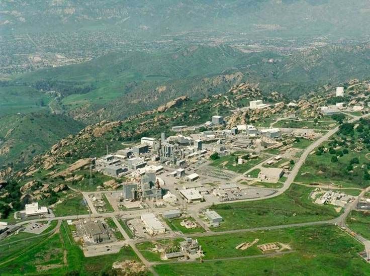
Photo: circa 1990, U.S. Department of Energy (Public Domain, via Wikimedia Commons)
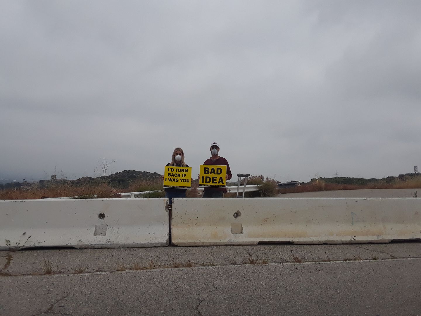
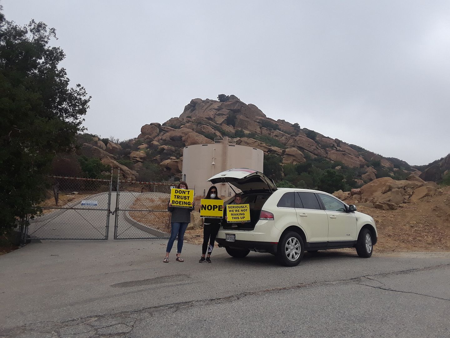
But when I was driving up Woolsey Canyon Road towards the Boeing security checkpoint, I was greeted by masked protestors telling me to "turn back."
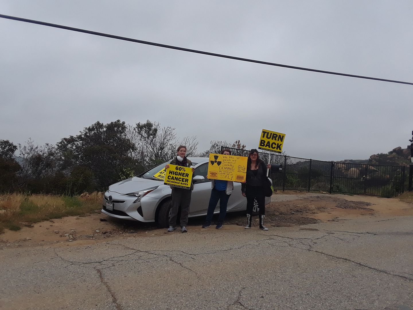
I stopped and said hello to each group of them, requesting a photo and asking why they were telling would-be hikers not to "support" Boeing by participating in its Earth Day activities. "Give me your pitch," I said.
I, of course, knew the dangers—having already visited five years ago and having (perhaps stupidly) spent time in Chernobyl in 2017. But all they could do was tell me that it wasn't safe—and that if I insisted on going, I should wear a mask (they provided one that's perfectly suitable for dust but not radioactive material), wash my clothes as soon as I got home, and leave my shoes outside the door.
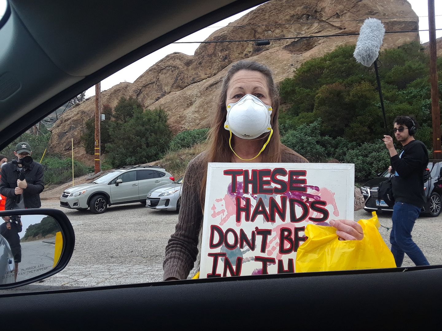
Of course, they're right. And I believed the local woman who told me about her own health issues, as well as those of her daughters. The decades of thyroid cancer, autoimmune diseases, mystery illnesses—it's all pretty well documented.
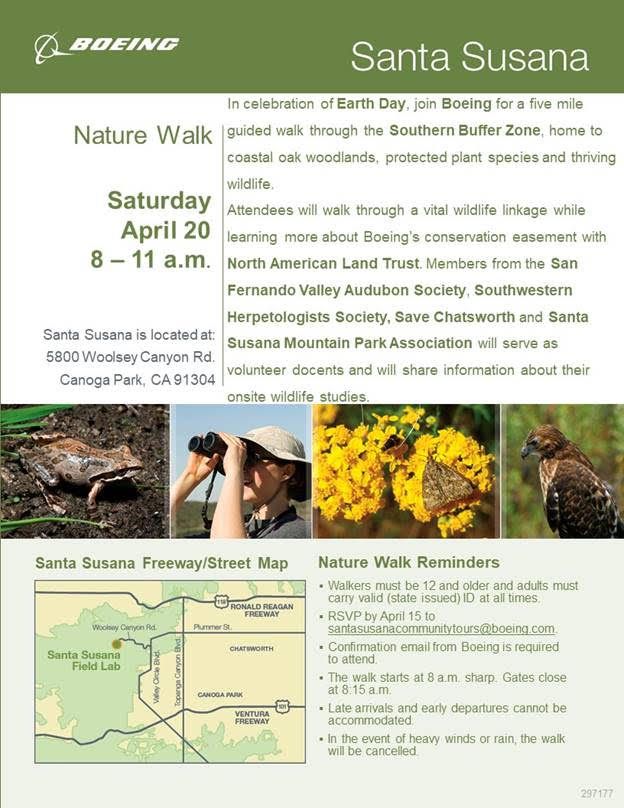
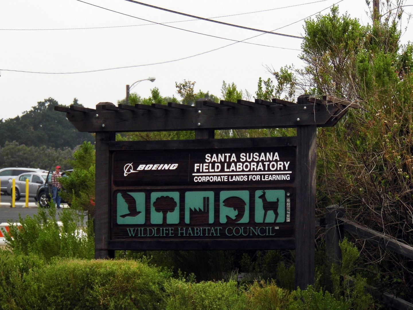
Photo: Santa Susana Community Tours
Having gotten my attention while so many other cars sped past me with my hazards on, the protestors begged me not to go. I told them not to worry: "They're probably not going to let me in anyway."
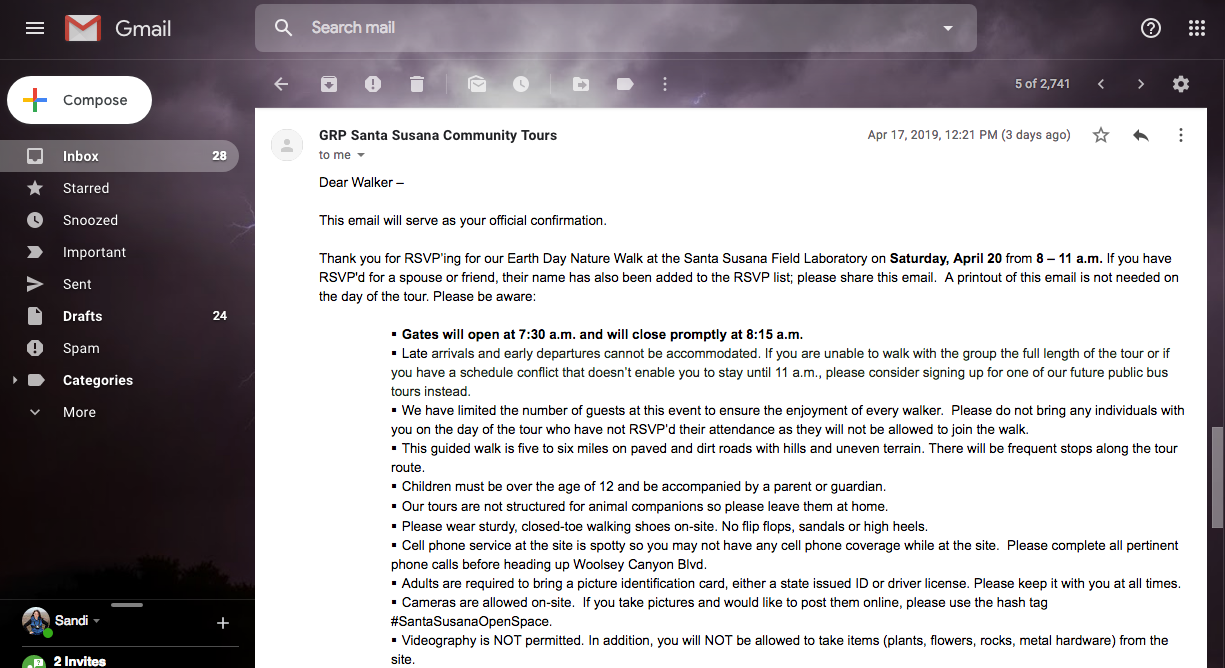
Because although I'd received my confirmation email three days ago, when I logged in to double-check the address earlier this morning, I discovered yet another email in my inbox.
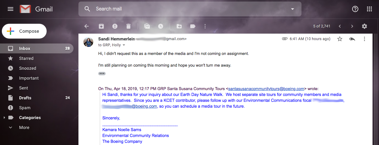
This one, from two days ago, read, "We host separate site tours for community members and media representatives. Since you are a KCET contributor, please follow up with our Environmental Communications focal...so you can schedule a media tour in the future."
I thought that was curious, since I wasn't attending as a media representative and definitely hadn't been assigned a story about the hike or Santa Susana in general. My KCET column is pretty fluffy—goat yoga, coffee culture, superblooms, and the like—and therefore innocuous.
You'd think, anyway.
I replied to their email—but it was so early in the morning, I suspected they might not receive it right away. So, I decided to show up anyway and try to clear up what must've been a simple misunderstanding.
But when I got there, my name wasn't on the list at the security checkpoint. The officers had me proceed past the kiosk and pull my car over.
One called the Boeing rep from Environmental Community Relations on his walkie. When he gave her my name, she responded, "Can you call me?"
When he returned to my car after calling her, he said, "They told me not to let you in."
There was a bit of back-and-forth after that, but it was clear that there was no getting in. So, I turned around and drive back past those protestors.
They nodded knowingly when I said that I was turned away for being "media."
Boeing couldn't possibly be blacklisting me because they didn't want journalists showing up, could they?
I mean, after all, everybody's a blogger or some kind of social media influencer these days. And although my Avoiding Regret readers are loyal, there's not a staggering number of them.
Boeing's confirmation email even encouraged photography and promoted the hashtag #SantaSusanaOpenSpace.
So what are they hiding? What would I, as a writer (or "media" person), pick up on that members of the general public would not?
What didn't they want me to see or hear?
What didn't they want me to tell?
The secret's already out about the Sodium Reactor Experiment nuclear meltdown of 1959 (one of the
And then there's the subsequent illegal disposal of nuclear waste.
What else could there possibly be?
Here's what I know from the internet:
- The Boeing Company has lined up a number of "third-party allies," including a Pennsylvania-based conservation management organization called North American Land Trust—a 501(c)(3) non-profit that holds a perpetually binding Conservation Easement on the property.
- Boeing has been certified by another 501(c)(3) non-profit—a DC area-based conservation organization called Wildlife Habitat Council, which works with corporate landowners to use their holdings in a way that's sensitive to wildlife.
- Other organizations working with Boeing include Santa Susana Mountain Park Association, San Fernando Valley Audubon Society, Southwestern Herpetologist Society, Pollinator Partnership (which has conducted onsite studies), and the Chumash and Tataviam Native American Tribes.
- Boeing isn't the only landowner of the former Rocketdyne site, but it's the only one to commit to permanently conserving its holdings (2,400 acres) as open space. NASA and the Department of Energy have put their parcels up for sale.
- There has been a movement to establish the site as a National Historic Monument, but no updates are available.
- Most documents and position statements available online are from 2013-17. There's nothing on the California Department of Toxic Substances Control's SSFL Document Library for 2018. It's hard to know exactly what's happening now and what's been decided—but originally, the SSFL was already supposed to be cleaned up by 2017.
- The public comment period for the the DTSC's Draft Environmental Impact Report has closed. Not sure when the final report will be released.
Meanwhile, the air quality report from 2Q 2018 shows that concentrations of at least one volatile organic compound—ethylbenzene, a possibly carcinogenic solvent used in the production of styrene—were higher at SSFL than what the EPA recommends for a residential area.
Levels of radioactive particles (a.k.a. radionuclides, like plutonium, radium, and uranium) were tested by collecting samples from glass fiber—but their method of testing introduced interference in all samples, which created a low bias in the results.
According to publicly available materials, there are two prevailing concepts that are largely informing Boeing's approach to the cleanup:
- That the contamination is isolated to the site, and therefore
- That the cleanup only needs to be held to the standards of an "occasional use" open space.
And there are two problems with those arguments:
- As we know from Chernobyl, radioactive material does, in fact, drift—with wind (which Santa Susana has plenty of), rain, and the resulting runoff. Polluted water pools at the lowest spot, which is both the "Southern Buffer Zone" (where the hike was held) and the neighboring communities below. Tests in surrounding communities have found Rocketdyne-associated contamination in groundwater and soil samples.
- People are already living so incredibly adjacent to the SSFL site—not the least of which are two mobile home communities, Summit and Mountainview Estates, both since 1979. A more recent addition includes the "upscale" and "prestigious" residential subdivision of Woolsey Canyon View Estates. The home closest to Boeing's security kiosk is a mere 1.1-mile drive away—or 0.7 miles as the crow flies.
For Boeing's position, you can read their Backgrounder sheet and one-pager on the EIR.
To hear the protestors' side of the story, you can visit the websites of such community-based alliances as Santa Susana Field Laboratory Work Group, Protect Santa Susana from Boeing, and Rocketdyne Cleanup Coalition.
I wish Boeing had given me the chance to see the recovery myself. I'd love to see some birds and lizards and plants and bees up there.
But maybe I dodged a radioactive bullet by being unceremoniously ejected from the site.
Nevertheless, it raises a bright, red flag.
Update 4/23/19:
Boeing Communications responded to my inquiry today with the following:
In part, it reads:
And I guess that means they must be Googling the names of all the registrants to make sure they're not "reporters."
This post will continue to be updated as new information comes in.
Related Posts:
Photo Essay: Boeing Rocketdyne Santa Susana Field Lab, Declassified & Decontaminating
Photo Essay: Crashing & Bleeding on the Trails at Sage Ranch
To hear the protestors' side of the story, you can visit the websites of such community-based alliances as Santa Susana Field Laboratory Work Group, Protect Santa Susana from Boeing, and Rocketdyne Cleanup Coalition.
I wish Boeing had given me the chance to see the recovery myself. I'd love to see some birds and lizards and plants and bees up there.
But maybe I dodged a radioactive bullet by being unceremoniously ejected from the site.
Nevertheless, it raises a bright, red flag.
Update 4/23/19:
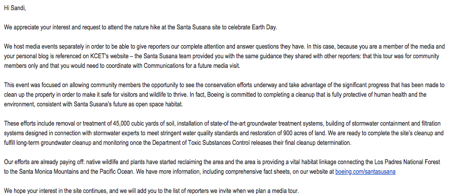
Boeing Communications responded to my inquiry today with the following:
In part, it reads:
We host media events separately in order to be able to give reporters our complete attention and answer questions they have. In this case, because you are a member of the media and your personal blog is referenced on KCET’s website – the Santa Susana team provided you with the same guidance they shared with other reporters: that this tour was for community members only and that you would need to coordinate with Communications for a future media visit.
This event was focused on allowing community members the opportunity to see the conservation efforts underway and take advantage of the significant progress that has been made to clean up the property in order to make it safe for visitors and wildlife to thrive. In fact, Boeing is committed to completing a cleanup that is fully protective of human health and the environment, consistent with Santa Susana’s future as open space habitat.I guess that means a writer can't be a member of the community—no matter what they write about.
And I guess that means they must be Googling the names of all the registrants to make sure they're not "reporters."
This post will continue to be updated as new information comes in.
Related Posts:
Photo Essay: Boeing Rocketdyne Santa Susana Field Lab, Declassified & Decontaminating
Photo Essay: Crashing & Bleeding on the Trails at Sage Ranch


